Enceladus Fly-by - 9 October 2008
7 October 2008
On 9 October 2008 Cassini will fly closer to the surface of Enceladus and deeper through the south polar plume than ever before. The closest approach occurs at 19:06:40 UT at an altitude of just 25 kilometres above the surface and at a relative speed of 17.7 kms-1. The latitude at closest approach is 28° S, the longitude is 97° W. Just 29 seconds after closest approach, Cassini will fly directly over the south pole at an altitude of 339 kilometres. Enceladus will enter eclipse ~46 minutes after closest approach, and remain in Saturn's shadow for 2.5 hours.The plume passage will allow in situ measurements by fields-and-particles instruments such as the Ion and Neutral Mass Spectrometer and the Cosmic Dust Analyzer, to gain an understanding of plume and surface composition.
This encounter will be set up with a manoeuvre on October 6. The Enceladus flyby occurs on the day of orbit number 88 periapse, on the inbound leg of the orbit.
Science Activities
- Imaging Science Subsystem (ISS)
Coverage of the south polar region during the EN-88 fly-by will be used to investigate plume temporal variability. - Composite Infrared Spectrometer (CIRS)
CIRS will make observations of the south polar temperatures during solar eclipse to determine the heat capacity and textural properties of the regolith. These maps will complement data obtained in the previous fly-by. During EN-88, while in sunlight, CIRS will focus on plume source III on Damascus Sulcus, and during eclipse will concentrate on Damascus and Baghdad sulci (tiger stripes), fill in gaps in spatial coverage, and look for time variability. - Visual and Infrared Mapping Spectrometer (VIMS)
VIMS will perform compositional mapping and will look for confirmation of weak spectral features such as those due to organics, CO2, ammonia, and other compounds. VIMS will search for hotspots with temperatures >140K. - Ultraviolet Imaging Spectrograph (UVIS)
UVIS will obtain spectral images of Enceladus in the EUV (500-1100 Å) and FUV (1100-1900 Å) to map the surface composition, including water ice abundances and grain sizes, and will search for volatiles in the vicinity of Enceladus. - Magnetospheric and Plasma Science (MAPS)
MAPS instruments will examine the particle environment at ~25 km from the surface during the fly-by. The fields-and-particles instruments will determine the nature of the material coming form the surface and its relationship to the E ring, and distinguish between two potential populations of particles: plume particles and sputtered particles from elsewhere on the surface (impactor ejecta). Optimal pointing during this fly-by coupled with the trajectory relative to the plume source should provide the highest signal and best INMS composition results to date. CDA measurements will determine the composition of surface ejecta and plume particles. The close fly-by distance will allow the magnetometer to determine whether Enceladus generates an induced magnetic field from a subsurface ocean. The magnetometer will also determine the composition of plume material from measurement of ion cyclotron waves in the magnetic field measurements. RPWS will study whether there is evidence for local ionization (other than charge exchange) in the plumes, the flux and size distribution of dust from the geysers, and the interaction between Enceladus and its magnetospheric environment. CAPS will study the ionosphere of Enceladus. - Cassini Radar (RADAR)
During the inbound leg of the EN-88 fly-by, RADAR will make scatterometry measurements to determine cm-scale roughness and radiometry measurements to understand the energy balance.
Table of events
13 September 2008
| Time UTC | Time wrt EN-88 |
Activity |
| 22:19:00 | -25d 21h | Start of sequence S44 which contains Enceladus-88 (EN-88) |
6 October 2008
| Time UTC | Time wrt EN-88 |
Activity |
| 12:05:00 | -03d 07h | OTM #166 prime. Enceladus-88 approach targeting manoeuvre |
7 October 2008
| Time UTC | Time wrt EN-88 |
Activity |
| 11:50:00 | -02d 07h | OTM #166 backup |
8 October 2008
| Time UTC | Time wrt EN-88 |
Activity |
| 20:50:00 | -22h 16m | Start of the SOST segment which contains Enceladus-88 |
| 21:35:00 | -21h 31m | Pre-Enceladus observations of Titan and Saturn aurorae |
9 October 2008
| Time UTC | Time wrt EN-88 |
Activity |
| 02:15:00 | -16h 51m | Inbound Enceladus plume and neutral gas observations (distant). A 4.25 hour medium-phase angle observation of Enceladus (inbound over northern hemisphere). With ISS and UVIS prime |
| 07:15:00 | -11h 51m | Downlink, 2.25 hr, Madrid 70m |
| 10:15:00 | -08h 51m | Deadtime, 15 minutes long. Used to accommodate changes in fly-by time |
| 10:30:40 | -08h 36m | Inbound RADAR scatterometry |
| 14:06:40 | -05h 00m | Inbound optical remote sensing (ORS) observations. CIRS prime - a series of scans and stares at Enceladus' north polar region |
| 17:06:40 | -02h 00m | Inbound ORS observations. UVIS prime - long slow scan starting off disk and ending on disk of Enceladus; search for neutral gases |
| 18:06:40 | -01h 00m | Transition to thruster control |
| 18:07:40 | -00h 59m | Closest-approach MAPS measurements. INMS prime - in situ plume measurements |
| 19:06:40 | +00h 00m | Enceladus-88 Fly-by Closest Approach Time. Altitude =25 km, speed = 17.7 kms-1, mid phase inbound, 112.5° phase at closest approach, mid phase outbound |
| 19:21:40 | +00h 15m | Outbound ORS observations. Outbound ISS multi-spectral mosaic of south pole |
| 19:49:40 | +00h 43m | Outbound ORS observations. CIRS eclipse measurements of south pole |
| 20:35:40 | +01h 29m | Transition to reaction wheel assembly control |
| 20:57:40 | +01h 51m | Outbound ORS observations. CIRS post-eclipse measurements of south pole |
| 20:57:40 | +01h 51m | Outbound ORS observations. UVIS prime - final long distant observation to map out the neutral oxygen around Enceladus and to observe Tethys |
10 October 2008
| Time UTC | Time wrt EN-88 |
Activity |
| 06:29:40 | +11h 23m | Deadtime, 15 minutes long. Used to accommodate changes in fly-by time |
| 08:00:00 | +12h 54m | Downlink, 12 hr 50 min, Madrid + Goldstone 70m |
Observation Results
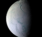
Cassini Instrument: Imaging Science Subsystem (ISS)
|
Date: 15 December 2008 Credit: NASA/JPL/Space Science Institute Image Notes: False-colour mosaic centred at ~65°S, 284°W, created from 28 NAC images that were each derived from data in several bands (between 338-930nm). |
 |