First Close Titan Flyby
25 October 2004
On Tuesday 26 October, Cassini-Huygens will have its first targeted flyby of Titan (Titan-A), the closest ever performed to date. This swingby will not only allow important surface and atmosphere science of Saturn's largest moon, but will also significantly change the spacecraft's orbit. The orbital period will decrease from 4 months to 48 days and a course will be set for the next close Titan flyby (Titan-B) on 13 December 2004.Cassini-Huygens' first close approach to Titan takes the spacecraft to an altitude of 1200 kilometres above the surface at a relative speed of 6.1 kms-1 (~21 960 kmh-1). Leading up to this encounter three manoeuvres were performed: the Periapsis Raising Manoeuvre and Periapsis Raise Manoeuvre cleanups, both of which took place successfully on 23 August and 7 September 2004, respectively; and the Titan minus three day targeting manoeuvre, performed on 23 October. Titan-A is an inbound flyby, with Saturn periapsis occurring about two days afterwards, on 28 October.
During approach to Saturn, and since orbit insertion, the navigation team has engaged in near-daily optical navigation of Titan and Saturn's other satellites in order to refine their orbit estimates as much as possible. They expect the spacecraft to be delivered within 30 km of the target altitude at a confidence of 99% (three sigma).
Science activities
The Cassini-Huygens mission will explore different aspects of Saturn's largest moon Titan. These include the interior structure, surface characteristics, atmospheric properties, and interaction with Saturn's magnetosphere.
The Titan-A flyby will be the first ever opportunity for up close observations of Titan's atmosphere. This will contribute significantly to atmospheric model updates necessary to validate the 950 km minimum flyby altitude of the mission's future Titan flybys and perhaps the Huygens mission profile as well. The sources of this improvement will come primarily from INMS data and AACS attitude control telemetry during the flyby.
Observations by the Cassini instruments during the Titan-A flyby include:
- CAPS will make its first measurements of Titan's upper ionosphere and gather science from Cassini's first crossing through Titan's plasma wake. CAPS will make both ion and electron measurements during the flyby, except for the period from about closest approach -85 to -30 minutes.
- CIRS will measure the stratospheric temperatures versus pressure (and therefore density), in part to contribute to the Huygens mission validation at the altitudes of parachute deployment.
- ISS will conduct its first medium and high resolution imaging of Titan, including imaging of the Huygens landing site. The cameras will perform distant observations at about 2.7 kilometres per pixel, a full-disk color mosaic at about 2 kilometres per pixel, regional to global mapping of the western bright/dark boundary at 200-600 metres per pixel, and very high resolution imaging of an edge of a bright area at 23-81 metres per pixel.
- INMS will perform the first ever in-situ measurements of Titan's upper atmosphere, to determine the density and composition.
- MAG will perform a detailed study of Titan's interaction with Saturn's magnetosphere during the entire flyby, as well as further constrain the possible internal magnetic field of Titan.
- MIMI will examine Titan's exosphere with ENA imaging and characterize the ion composition and charge state near Titan.
- RADAR will perform its first Synthetic Aperture Radar (SAR) imaging of Titan's surface, as well as scatterometry of the Huygens landing site. Scatterometry should provide roughness and solid/liquid discrimination, and radiometry should contribute to temperature mapping.
- RPWS will take measurements while passing through Titan's ionosphere and contribute to the understanding of Titan's interaction with Saturn's magnetosphere.
- UVIS will perform two high resolution scans across Titan to investigate the composition and distribution of aerosols.
- VIMS hopes to perform surface composition and fluid feature mapping (lakes, rivers), as well as see aerosol and cloud structures in the atmosphere, methane fluorescence and look for volcanic activity. They also contribute to mapping of the Huygens landing site at 1 km spatial resolution.
Table of events
25 October 2004
| Time UTC | Time wrt Titan-A |
Event |
|
17:16 |
- 22h 14m | Begin approach observations |
26 October 2004
| Time UTC | Time wrt Titan-A |
Event |
| 13:42 | - 01h 48m | Transition to thruster control |
| 15:30 | + 00h 00m | Titan-A closest approach |
| 15:30 | + 00h 00m | Begin high resolution RADAR SAR imaging |
| 15:36 | + 00h 06m | Begin low resolution RADAR SAR imaging |
| 15:46 | + 00h 16m | Begin RADAR altimetry |
| 16:45 | + 01h 15m | Transition back to reaction wheels |
| 16:53 | + 01h 23m | Ascending ring plane crossing |
27 October 2004
| Time UTC | Time wrt Titan-A |
Event |
| 00:16 | + 08h 46m | Begin playback of Titan-A data |
| 00:27 | + 08h 57m |
First Titan-A images returned |
| 05:26 | + 13h 56m | Highest resolution images returned |
| 06:16 | + 14h 46m | RADAR SAR data returned |
| 09:16 | + 17h 46m |
End playback of Titan-A data |
28 October 2004
| Time UTC | Time wrt Titan-A |
Event |
| 10:19 | + 01d 19h | Saturn periapse, closest approach to Saturn at 6.2 Saturn radii, 104° phase angle |
|
19:59 |
+ 02d 04h | Descending ring plane crossing: 8.1 radii from Saturn, cross through outer edge of E ring |
Details of events
 |
|
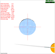
Orbital conditions during encounter |
View of the Huygens landing site
 |
|
Nearing Titan, 1.5 hours before closest approach. |
There will be excellent visibility of the foreseen Huygens landing site at around 167° E and 10.7° S on the sunlit face of Titan before reaching the point of closest approach.
The image on the right is an impression of the approach to Titan, around 1.5 hours prior to Titan-A closest approach. The Huygens touchdown region, including uncertainties, can be seen as a pink stain just above the left horizontal bar of the crosshairs. Although the distance at that time is still 31 000 km, the visibility conditions shown here are typical for the approach and should allow infrared and radar viewing of the surface region in that area. Closest approach is near the terminator and therefore too far to the East from the landing zone to allow a detailed view.
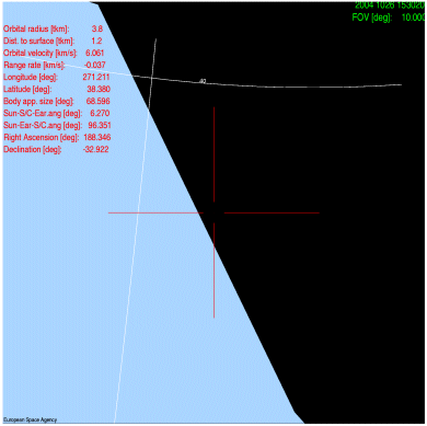
Closest Approach to Titan
 |
|
View of Titan at the point of closest approach, with an assumed Field of View of 20°. This is still much larger than that of the Wide-Angle-Camera (3.43°). The terminator is seen running from top-left to bottom-right. |
Tuesday 26 October 2004 16:44 UTC. Minimum altitude: around 1200 km over the surface, almost grazing the outer atmosphere. The peak velocity relative to Titan will be 6.1 kms-1 (21 960 kmh-1).
At closest approach, Titan, which has a diameter of 5150 km and appears even larger because of its atmosphere, will have an apparent size of 68.6°, far exceeding the field of view of the Imaging Science Subsystem (ISS). It probably will not be possible to use the ISS at closest approach because of the large relative speed, but if one could, the maximum resolution of the image gained with the narrow angle camera would be around 7 metres. Cassini-Huygens appproaches from the sunlit side and recedes over the night side.
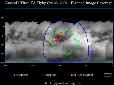
Titan Surface Coverage
The map below (released by NASA) of Titan's surface, was generated from images taken during Cassini's approach to Saturn, illustrates the imaging coverage planned during the flyby.
 |
|
Image courtesy NASA/JPL/Space Science Institute |
Coloured lines enclose regions that will be covered at different imaging scales as Cassini approaches Titan. Based on previous observations, it is anticipated that the size of the smallest visible surface features will be approximately five times larger than the image scale. Thus, the smallest visible features within the region bounded by the red curve should be about 1 to 1.2 kilometres across. The yellow X marks the predicted landing site for the Huygens probe, the target of the camera's highest-resolution mosaic. Images of this site taken near closest approach may have higher resolution than indicated here. Features a few hundred metres across may be discernible, depending on the effect that relative motion between the spacecraft and Titan has on the quality of the images.
The images used to create the map were acquired between April and June 2004 using a narrow, 938-nanometre filter that sees through Titan's atmospheric haze to the surface. These images have been processed to enhance surface details. Scales range from 88 to 35 kilometres per pixel. It's currently winter in Titan's northern hemisphere, so high northern latitudes are not illuminated, resulting in the map's upper limit at roughly 45 degrees north latitude.
Observation Results
For a summary of the flyby results, see the link "Successful Titan-A Flyby" on the right-hand side.
