Roman Empire remembered on maps of asteroid (21) Lutetia
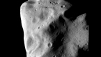
Almost the entire northern hemisphere and parts of the southern hemisphere were imaged by the wide and narrow angle cameras of the OSIRIS instrument. These unprecedented images enabled the Rosetta science team to identify seven distinct topographic and geological regions, which were named after provinces of the ancient Roman Empire: Baetica, Achaia, Etruria, Narbonensis, Noricum, Pannonia and Raetia. The unobserved area of the southern hemisphere was named after Hermann Goldschmidt, who discovered asteroid Lutetia in 1852.
 |
|
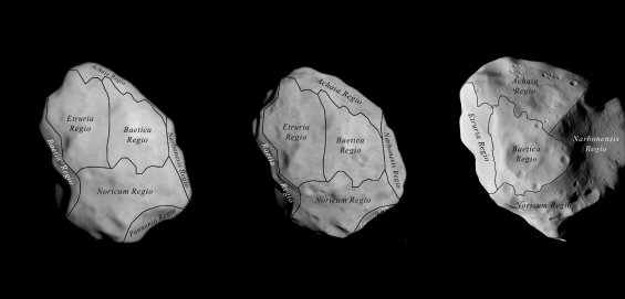
A Rosetta map of asteroid (21) Lutetia showing the newly identified regions. Credit: ESA 2010 MPS for OSIRIS Team MPS/UPD/LAM/IAA/RSSD/ INTA/UPM/DASP/IDA |
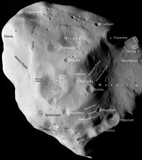 |
| An annotated map of asteroid (21) Lutetia. Credit: ESA 2010 MPS for OSIRIS Team MPS/UPD/LAM/ IAA/RSSD/INTA/ UPM/ DASP/IDA |
The most notable impact craters were named after cities which existed around the same time as the city of Lutetia (the Roman name for Paris, France). The largest of all is the 55-km diameter Massilia, the Roman name for Marseille. Other features have been named after rivers of the Roman Empire and adjacent parts of Europe at the time of Lutetia.
Rosetta's flyby trajectory meant that the asteroid's north pole, located in the Baetica region, was fully illuminated by sunlight. The western hemisphere (the Raetia and Etruria regions) was seen to lower latitudes at low resolution during the approach, whereas the eastern hemisphere (Narbonensis) was seen at higher resolution but at a high phase angle. As a result, more shadows were seen in the east.
Five of the major regions were observed during the closest approach, whilst two others (Pannonia and Raetia) were imaged at lower resolution and defined on the basis of sharp morphological boundaries such as crater walls and ridges.
A cluster of craters close to the north pole in the Baetica region is one of the most prominent features of the northern hemisphere. The most heavily cratered, and therefore oldest, regions (Noricum and Achaia) are separated by the Narbonensis region, which is defined by the Massilia crater. This crater contains several smaller units, and is deformed by grooves and pit-chains, indicating modifications that took place after its initial formation. Another large impact crater was seen close to the limb in the Raetia region.
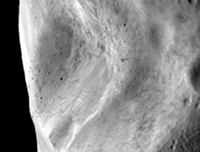 |
| A close-up of the central crater in the Baetica region showing landslides. Credit: ESA 2010 MPS for OSIRIS Team MPS/UPD/LAM/ IAA/RSSD/INTA/ UPM/ DASP/IDA |
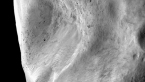
The relatively young crater cluster in Baetica contains boulders up to 300 metres across - probably impact debris. These were among the largest rocks found so far on small bodies in the Solar System. Huge landslides, which seem to have occurred after the boulders were deposited, have blanketed much of the crater floors.
The older, more cratered surfaces of Lutetia also feature a variety of roughly parallel, curvilinear features, including scarps, troughs, fractures, faults, grooves and pit chains. The linear features are similar in appearance to those on the Martian moon Phobos, where they are commonly interpreted as resulting from a large impact. The pattern of grooves on Lutetia suggests strain structures or fractures within a solid body of considerable strength.
A number of scarps and other linear features transect several small craters. However, their orientations are different in each region and they do not appear to bear any obvious relationship to the major craters. Other curvilinear features appear to be buried by impact ejecta from the Baetica region.
In the Noricum region, one prominent scarp bounds a local topographic high where the lineaments run almost parallel to the scarp and to the rims of the crater cluster in Baetica. This area of highland in Noricum also displays a trough - probably fault-guided - which is more than 10 km long and roughly 100 m deep.