Mare Humorum Basin
Date: 26 April 2006
Satellite: SMART-1
Depicts: Lunar Surface
Copyright: ESA/SPACE-X (Space Exploration Institute)
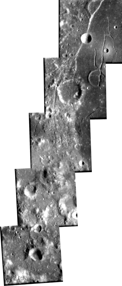
This sequence of images, taken by the advanced Moon Imaging Experiment (AMIE), shows an area on the near side of the Moon, on the edge of the Mare Humorum basin. The field of view of each single image is about 50 kilometres. North is up.
The flat lava plain in the upper right image is the floor of Mare Humorum. The bowl-shaped crater on top, cut by a fracture, is called Liebig F and has a diameter of nine kilometres.
The Mare Humorum impact basin is 825 kilometres across. Its precise age could not be determined by previous lunar programmes, but geologic mapping suggest it could be around 3.9 thousand million years old. This puts Mare Humorum's age between those of the Imbrium and Nectaris Basins.
The Humorum basin is filled with a layer of basalt, likely over three kilometres thick at its centre. The Humorum basin, like several other lunar basins, was formed in a period which ended around 4.1 billion years ago. It was filled with mare material - basaltic flood eruptions caused by very large meteoroid impacts - only during the later Eratosthenian era, in a period comprised between 3.9 and 3.2 billion years ago. The western edge of the sea is marked by a network of cracks and clefts following the Rupes Liebig.
The three northern images include part of the flat darker area corresponding to the mare basalt filling the inner ring of the basin impact. A fresh small crater is surrounded by brighter deposits.
The top north image also shows giant lava tubes or rilles in the Mare. Some graben-lineated structures (a graben is an elongated and relatively depressed crustal block between two fault systems) indicate the stress structures that were created during the multi-ring collapse, and were refreshed by additional load deformation from the weight of later basalt fill.
Towards the south, the landscape in these images shows a transition to that of a typical old cratered highland. In the middle image the small craters are not very clear because the terrain has been partly covered by material ejected from the impact basin.
|
Parameter |
Value |
| Date |
13 January 2006 |
| Distance |
1031 km - 1107 km |
| Longitude |
45.7° W |
| Latitude |
24.5° - 30.5° S |
| Resolution |
93 m/pixel - 100 m/pixel |