Crater Mezentsev Annotated
Date: 09 August 2006
Satellite: SMART-1
Depicts: Region around crater Mezentsev
Copyright: ESA/SPACE-X (Space Exploration Institute)
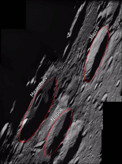
This image was taken by the Advanced Moon Imaging Experiment (AMIE) on 16 May 2006. The imaged area is centred at a latitude of 73° North and a longitude of 124° West, on the far side of the Moon.
Normally, the AMIE camera is pointed straight down at the lunar surface, in the Nadir pointing mode. In this image, AMIE was pointed towards the horizon, showing the lunar surface in an oblique view.
The largest craters in this image are Mezentsev, Niepce and Merrill. Mezentsev is an eroded crater 89 kilometres in diameter and centred at 72.1° N, 128.7° W. A smaller cup-shaped crater resides inside Mezentsev. Niepce and Merrill both have a diameter of 57 km and are located at 72.7° N, 119.1° W, and 75.2° N, 116.3° W, respectively.
Mezentsev is named after Yourij Mezentsev, a Soviet engineer (1929 - 1965) who was one of the first people to design rocket launchers. Joseph Niepce was the French inventor of photography (1765 - 1833); Paul Merrill was an American astronomer (1887 - 1961).
|
Parameter |
Value |
| Date |
16 May 2006 |
| Longitude |
124° W |
| Latitude |
73° N |
