Floor of Crater Jacobi

Date: 14 August 2006
Satellite: SMART-1
Depicts: Floor of lunar crater Jacobi
Copyright: ESA/SPACE-X (Space Exploration Institute)
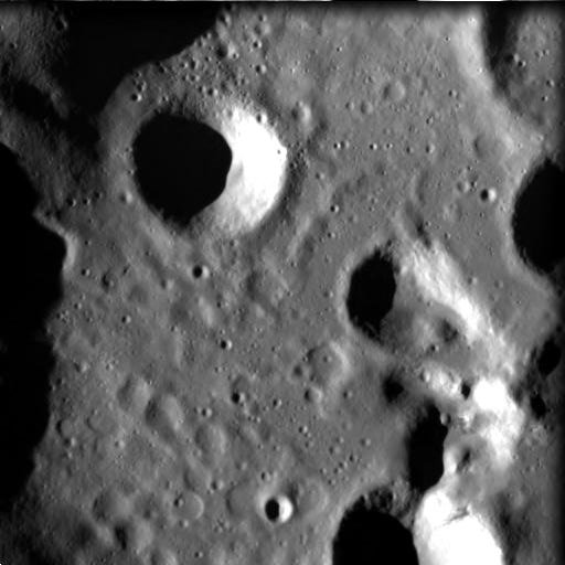
This high-resolution image was taken by the advanced Moon Imaging Experiment (AMIE) on 18 March 2006 from a distance of about 578 kilometres from the Moon's surface, with a ground resolution of 52 metres per pixel.
It shows part of crater Jacobi in the Moon's southern hemisphere. The western crater rim can be seen on the left edge of the image. The imaged area is centred at a latitude of 56.5° South and a longitude of 10.9° East, with a field of view of 27 km. North is up.
Crater Jacobi itself is much larger than this image - 68 kilometres in diameter - with the imaged area only showing about one fifth of the crater floor area. The crater is centred at a latitude of 56.7° South and a longitude of 11.4° East. The single prominent crater to the upper left of the image centre is Jacobi W, with a diameter of only 7 kilometres.
Peculiar surface structure can be seen in the lower left part of the image, and indicates several heavily eroded kilometre-sized craters. SMART-1 resolution at high solar elevation angle allows for the detection of eroded structures buried under more recent layers, giving a window on the past evolution of the Moon.
The crater is named after the German mathematician Karl Gustav Jacob Jacobi (1804 - 1851), who worked on elliptic functions and was active in the field of celestial mechanics.
| Parameter | Value |
| Date | 18 March 2006 |
| Distance | 578 km |
| Longitude | 10.9° E |
| Latitude | 56.5° S |
| Resolution | 52 m/pixel |