Ridge of Crater Cuvier

Date: 22 August 2006
Satellite: SMART-1
Depicts: North-eastern part of crater Cuvier
Copyright: ESA/SPACE-X (Space Exploration Institute)
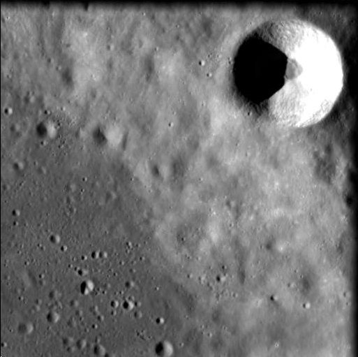
The Advanced Moon Imaging Experiment (AMIE) on board SMART-1 obtained this image on 18 March 2006 at a distance of 591 kilometres from the surface, with a ground resolution of 53 metres per pixel. The imaged area is centred at a longitude of 11.2° East and a latitude of 50.1° South, with a field of view of 27 km. North is up.
The image shows the north-eastern part of crater Cuvier, an old circular crater on the lunar near side, 77 kilometres in diameter. The smooth crater floor is visible in the lower left quadrant of the image. Situated on the rim of crater Cuvier at the top right in this view is the smaller satellite crater, Cuvier C, with a diameter of 9 km.
The resolving power of AMIE allows for detailed measuring of rim and crater morphology in order to diagnose lunar impact processes. The AMIE data is also used to establish the statistics of small lunar craters for lunar chronology studies.
Crater Cuvier was named after the creator of the comparative anatomy, Georges Cuvier, a 19th century French naturalist (1769 - 1832).
| Parameter | Value |
| Date | 18 March 2006 |
| Distance | 591 km |
| Longitude | 11.2° E |
| Latitude | 50.1° S |
| Resolution | 53 m/pixel |