No. 88 - Trajectory Control Manoeuvre
| DOY | Date | Pass | Main Activity |
| 286 | 13/10/07 | NNO 1323 | Tracking Pass |
| 287 | 14/10/07 | NNO 1324 | Tracking Pass |
| 288 | 15/10/07 | NNO 1325 | Tracking Pass |
| 289 | 16/10/07 | NNO 1326 | Monitor, OSIRIS AR recovery activities |
| 290 | 17/10/07 | NNO 1327 | Uplink of TCM commands |
| 291 | 18/10/07 | NNO 1328 | TCM @ ESB2-4w |
| 292 | 19/10/07 | NNO 1329 | Monitor |
| 293 | 20/10/07 | NNO 1330 | Tracking Pass |
| 294 | 21/10/07 | NNO 1331 | Tracking Pass |
| 295 | 22/10/07 | NNO 1332 | Monitor |
| 296 | 23/10/07 | DSS-15 1333 | Tracking Pass |
| 298 | 25/10/07 | DSS-25 1335 NNO 1335 |
Tracking Pass Monitor |
| 299 | 26/10/07 | DSS-24 1336 | Tracking Pass |
At the end of the reporting period (DOY 299) Rosetta was at 15.8 million km from Earth (0.1 AU; one-way signal travel time was 53 seconds). The distance to the Sun was 164 million km (1.09 AU).
Spacecraft
Spacecraft
On DoY 2007.291 a trajectory correction manoeuvre (3.4 cm per second) took place. The spacecraft behaved properly during the manoeuvre. The timing of the manoeuvre was as follows:
- entry in GSP @ 16.04.55
- OCM duration 46 seconds (OCM entry @ 17.09.54 TTM entry @ 17.10.40)
- entry in WDP @ 17.11.12
- entry in GSP @ 17.40.05
- entry in GSEP @ 18.39.55
The RCS fuel consumption 38 Grams.
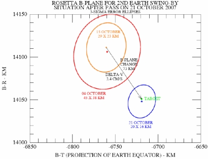
On the plot below, the red cross and surrounding 3-sigma error ellipse were the estimates for the location in the Rosetta B-plane, corresponding to the 2nd Earth swing-by, that were made on the basis of an orbit determination using data from the time of NSHM exit up to the end of the pass on 04 October.
 |
The orange cross and surrounding 3-sigma error ellipse were the estimates made on 15 October that were used to plan the trajectory control manoeuvre (TCM) that was executed on 18 October. Using data up to the end of the NNO pass on 21 October, the blue cross and surrounding 3-sigma error ellipse shows the current estimate in the B-plane. The location is 3 km from the target. The target location corresponds to a perigee altitude of 5299 km (relative to the Earth's equatorial radius). The estimate corresponds to an altitude of 5296.8 km with a 3- sigma uncertainty of 17.0 km.
The estimated time of closest approach (perigee passage) is 20:57:22.9 UTC on 13 November.
The 3-sigma uncertainty is now 2.6 seconds.
From the B-plane plot it is obvious that the TCM performance was near nominal. However, it was very small and the information content within the tracking data is not sufficient to give a precise calibration. If the manoeuvre direction was perfect then from the change in the Doppler it would be known that the manoeuvre overperformed by 2.6%. But the calibration within the orbit determination gives a small direction error so that the overperformance estimate is reduced to +0.6% (+0.2 mm/s). The 1-sigma uncertainty on this value is 2.9% (1.0 mm/s).
Payload
During the reporting period limited activities have been conducted with the payload complement.
ALICE
Instrument is OFF
CONSERT
Instrument is OFF
COSIMA
Instrument is OFF
GIADA
Instrument is OFF
MIDAS
During the reporting period very limited activities have been conducted with the payload complement for anomaly report recovery actions.
MIRO
Instrument is OFF
OSIRIS
Instrument is OFF.
ROSINA
Instrument is ON (RTOF in stand-by) as part of an out-gassing attempt.
RPC
Instrument is OFF.
RSI
Is in muted status
VIRTIS
Instrument is OFF.
LANDER Philae
Instrument is OFF.
SREM
Since DoY 248/2007 the accumulation settings are configured for active cruise mode.
Future Milestones
The preparation of the Earth Swing-by phase is proceeding according to the plan. Latest orbit determination indicates that a trajectory correction manoeuvre at ESB2-2w is very likely not needed. A final decision will be taken on 30 October with the most up-to-date navigation data. The closest approach during the swing-by will take place on the 13th of November at 20:57 UTC.

